MAYA KARIMATA ISLAND
Profile
Group: Archipelago: Borneo
Country: Indonesia - Kalimantan
Lat: 1.15º S Long : 109.55º E
Area: 992.1 sq. km Altitude: 509 m
Shoreline: 140.5 km (scale 1:1000000) Coastal Index: 0.1416
Depth to nearest land: <100 m Island only isolated since last ice age
Nearest island: 1 km group: 1 km
Nearest continent: Asia Distance: 650 km Isolation Index: 27
ISLAND TYPE: Natural Protection Indicator: 0
CLIMATE: tropical
ECOSYSTEMS:
HUMAN OCCUPATION: Inhabited, town of Tanjungsatai Population: 0 Density: 0.0 persons/sq. km Percent population in agr/mining/fishing: 55% Human Threat Indicator: 2 Gross Domestic Product: $ 566 per capita Economic Pressure Indicator: 0
About Maya Karimata Island
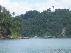
Karimata Island lies to the northeast of Serutu Island, in the middle of the Karimata Strait. It is inhabited by fishermen and has a lighthouse. The islands in its surroundings are Meladang, Buwan, Penebangan, Pelapis and other, smaller islands, totaling 54.
South of Ketapang, reachable from Kendawang, are two islands with beautiful beaches Bawal and Gelam. Although still rarely visited and little known, these islands hold great potential for the future. However the Maya Island is nearest to the Kalimantan mainland and is the biggest island of the group. Tanjungsatai, with a population of approximately 5,000 people, mostly fishermen, is the biggest and most important village on the island. Each of the smaller villages in its surroundings has a population of several hundred people only.
Maya Karimata (also called Maya or Maja) is an island in Ketapang district in Kalimantan Province, Indonesia. Its area is 992,1 km2. It belongs to the Borneo archipelago and is situated at Lat: 1.15º S Long : 109.55º E The highest altitude of the island is 509 m. It has a shoreline of 140.5 km Chief town is Tanjungsatai
Karimata Islands are located approximately 100 kilometers west of the city Ketapang. Geographically, the area is on 108o40 '- 109o10' BT and 1o25 '- 1o50' LS. Conservation area set in 1995 is 77,000 hectares. Karimata Islands consist of two large islands, namely Pulau Karimata and cigar and a few other small islands. Topography such as lowland areas up to high, from 0 - 1030 meters above sea level. Only in the two islands which is inhabited by people.
Karimata Islands can be reached from the city of Pontianak using a motor boat with 18 hours of the time. Given the difficulty in reaching the area, activity area management is still relatively small compared to other regions. Karimata Islands ecosystem diversity has good land and ecosystems marine ecosystem, including the variety of fish and coral reef marine ornamental. Several types of flora and fauna are endemic to the archipelago is quite unique in this beauty island.
Group: Archipelago: Borneo
Country: Indonesia - Kalimantan
Lat: 1.15º S Long : 109.55º E
Area: 992.1 sq. km Altitude: 509 m
Shoreline: 140.5 km (scale 1:1000000) Coastal Index: 0.1416
Depth to nearest land: <100 m Island only isolated since last ice age
Nearest island: 1 km group: 1 km
Nearest continent: Asia Distance: 650 km Isolation Index: 27
ISLAND TYPE: Natural Protection Indicator: 0
CLIMATE: tropical
ECOSYSTEMS:
HUMAN OCCUPATION: Inhabited, town of Tanjungsatai Population: 0 Density: 0.0 persons/sq. km Percent population in agr/mining/fishing: 55% Human Threat Indicator: 2 Gross Domestic Product: $ 566 per capita Economic Pressure Indicator: 0
About Maya Karimata Island
Karimata Island lies to the northeast of Serutu Island, in the middle of the Karimata Strait. It is inhabited by fishermen and has a lighthouse. The islands in its surroundings are Meladang, Buwan, Penebangan, Pelapis and other, smaller islands, totaling 54.
South of Ketapang, reachable from Kendawang, are two islands with beautiful beaches Bawal and Gelam. Although still rarely visited and little known, these islands hold great potential for the future. However the Maya Island is nearest to the Kalimantan mainland and is the biggest island of the group. Tanjungsatai, with a population of approximately 5,000 people, mostly fishermen, is the biggest and most important village on the island. Each of the smaller villages in its surroundings has a population of several hundred people only.
Maya Karimata (also called Maya or Maja) is an island in Ketapang district in Kalimantan Province, Indonesia. Its area is 992,1 km2. It belongs to the Borneo archipelago and is situated at Lat: 1.15º S Long : 109.55º E The highest altitude of the island is 509 m. It has a shoreline of 140.5 km Chief town is Tanjungsatai
Karimata Islands are located approximately 100 kilometers west of the city Ketapang. Geographically, the area is on 108o40 '- 109o10' BT and 1o25 '- 1o50' LS. Conservation area set in 1995 is 77,000 hectares. Karimata Islands consist of two large islands, namely Pulau Karimata and cigar and a few other small islands. Topography such as lowland areas up to high, from 0 - 1030 meters above sea level. Only in the two islands which is inhabited by people.
Karimata Islands can be reached from the city of Pontianak using a motor boat with 18 hours of the time. Given the difficulty in reaching the area, activity area management is still relatively small compared to other regions. Karimata Islands ecosystem diversity has good land and ecosystems marine ecosystem, including the variety of fish and coral reef marine ornamental. Several types of flora and fauna are endemic to the archipelago is quite unique in this beauty island.
CAMEL MOUNTAIN
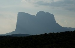
BUKIT BATU DAYA (CAMEL MOUNTAIN) Bukit Batu daya is the miracle of distrik Ketapang. This tour object is located on Simpang Hilir district 90 km from Ketapang city. This object characteristic is the shape of the mountain is resemble like a camel if we see it from the south (Where as this mountain is consist of three hill). Besides that for mountain climber can try the power of the mountain because the declivity of the mountain side is about 90 degrees.
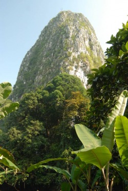
When you go to the District of Ketapang to see a variety of natural beauty, it is no less interesting unique "Stone Mountain Resources." Gunung Batu which is similar to the dark hills in the district is located in Sintang District. Stone mountain, this is one of the tourism Ketapang that have not been many. Giant pile of stone is a natural phenomenon miracle. Kec community. Bent mountain is named with the name "Mount bushel" because that is shaped like a bushel tool of rice. It's also called the "Power Hill" because when viewed from the other side it often change color so that we could be fool, and that is we called it "terpedaya" or fool.
Many of the mysteries that have not been revealed from the mountain rock, the geological processes and events of this stone is not much revealed. In addition, no less interesting diversity of flora and fauna in this area is very interesting to be inspected. According to the Notes in the World KIPDE international and national level, especially for cliff climber, the long hill with a "camel Hill" because the shape is similar to the camel back. With steep slope that has become a challenge for the hill climber, so at the national and international area is already included in the list of their agenda.
To go to this area you can drive through the water with boat speed through the district through Simping and Melano rivers. It also can be by road, from either direction and through Kendawangan municipality. Tumbang Titi. Other supporting facilities for the traveler is still limited, its location in the remote district, so restaurants and lodging facilities do not yet exist. Because of the name of this Camel Mountain is internationally recognized, I think it is not too difficult if we sell the name for the hill is a tourist, especially for the rock climbing followers, nature lovers and researchers. Local government also began to improve road facilities to the area, some roads are also under way across to go to this district, so that will shorten the distance.
Visit West Kalimantan Adventure Tours Kalimantan exudes cultural and rainforest wealth within its 540,000 sq. km. area and is ideally suited for trekking expeditions through connected trails that lead into primarily virgin forest.
In the hinterland the villages can only be reached by foot or missionary aircraft. The jungle trails range from 2 hours to weeks in length, depending on the route you choose. Dense jungles and wide terrain of wetlands have traditionally kept the region isolated from all but the most adventurous travelers. A virtual mosaic of traditions flourish in the bustling seaports and riverside cities and along the upper reaches of rivers, Dayak cultural treasures survive deep within the rainforests.
Visiting the indigenous Dayak settlements along Kalimantan’s rivers is an ideal way to experience the incredible culture, where village elders practice traditional medicine and mark their status with intricate body tattoos and remarkably heavy ear adornments. We will be warmly welcomed guests in their traditional longhouses.
Our goal is to provide insightful experiences to our guests: traditional culture, a grand diversity of exotic flora and wildlife from black orchids to freshwater dolphins and orangutans, captivating jungle explorations and unforgettable encounters in our village visits. utmx_section("dayak")3 and 4 Days Dayak Longhouse Tour at West Kalimantan Province Visit the Traditional Dayak Iban village Kampung Saham at Indonesia West Kalimantan Province. On th way we will see farmers working on their plantantions and make a stop at The Dai Nippon Navy World War II Monument....full itinerary
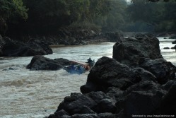
utmx_section("rapids")6 Days Serimbu Rapids Adventure Tour at West Kalimantan Visit the Traditional Dayak Iban village Kampung Saham at Indonesia West Kalimantan Province. On th way we will see farmers working on their plantantions and make a stop at The Dai Nippon Navy World War II Monument, Cruise from Ngabang the River into the rapids of Riam Pulau, Riam Panjang and Riam Jambu respectively. which are situated at a distance giving increasing challenge as the boat passing through them apart from many minor rapids you are going to encounter.This unique challenging rapids adventure is conducted using local boats with highly experienced boatmen to enable the trip. The tour also gives you an outlook of the only area in West Kalimantan that produces diamond apart from gold.You are indeed welcome to try the traditional way of panning gold or diamond during the trip. Observe closely the living cultures and social structures in the jungle. In person you’ll experience the jungle-life and getting to know more people, filling your heart with their cheerful laughter. This adventure tour is only organised in its main features and so it will always be an adventure, which is depending on weather and river conditions....full itinerary
utmx_section("kelam")7 Days Mount Kelam Expedtition Tour at West Kalimantan Cruising the Kapuas River from Sintang to Kebiau River, Trekking the jungle to Sabang Laja Village following tracks to Ensait Panjang. There are two Ensait Long-houses : Ensait Panjang and Ensait Pendek, situated at a distance. We pass through Ensait Pendek and stay overnight in Ensait Panjang. Dinner will be served together with the community and hospitality with the chief. Here we can see how they traditionally weave clothes, plait baskets. Climbing The Mount Kelam from where you can see the Green Flora and Fauna Beauty of Indonesia West Borneo Province...full itinerary
utmx_section("Palung")7 Days Gunung Palung National Park at West Kalimantan Province Gunung Palung National Park with it's unique flora and fauna and wild life including the Orangutan, can be found here, while it always will be a luck to spot them in the wild habitat.Jungle Trekking , Bird watching and spotting different types of wild life and exotic flora and fauna at Gunung Palung National Park of West Kalimantan Province.....full itinerary
In the hinterland the villages can only be reached by foot or missionary aircraft. The jungle trails range from 2 hours to weeks in length, depending on the route you choose. Dense jungles and wide terrain of wetlands have traditionally kept the region isolated from all but the most adventurous travelers. A virtual mosaic of traditions flourish in the bustling seaports and riverside cities and along the upper reaches of rivers, Dayak cultural treasures survive deep within the rainforests.
Visiting the indigenous Dayak settlements along Kalimantan’s rivers is an ideal way to experience the incredible culture, where village elders practice traditional medicine and mark their status with intricate body tattoos and remarkably heavy ear adornments. We will be warmly welcomed guests in their traditional longhouses.
Our goal is to provide insightful experiences to our guests: traditional culture, a grand diversity of exotic flora and wildlife from black orchids to freshwater dolphins and orangutans, captivating jungle explorations and unforgettable encounters in our village visits. utmx_section("dayak")3 and 4 Days Dayak Longhouse Tour at West Kalimantan Province Visit the Traditional Dayak Iban village Kampung Saham at Indonesia West Kalimantan Province. On th way we will see farmers working on their plantantions and make a stop at The Dai Nippon Navy World War II Monument....full itinerary
utmx_section("rapids")6 Days Serimbu Rapids Adventure Tour at West Kalimantan Visit the Traditional Dayak Iban village Kampung Saham at Indonesia West Kalimantan Province. On th way we will see farmers working on their plantantions and make a stop at The Dai Nippon Navy World War II Monument, Cruise from Ngabang the River into the rapids of Riam Pulau, Riam Panjang and Riam Jambu respectively. which are situated at a distance giving increasing challenge as the boat passing through them apart from many minor rapids you are going to encounter.This unique challenging rapids adventure is conducted using local boats with highly experienced boatmen to enable the trip. The tour also gives you an outlook of the only area in West Kalimantan that produces diamond apart from gold.You are indeed welcome to try the traditional way of panning gold or diamond during the trip. Observe closely the living cultures and social structures in the jungle. In person you’ll experience the jungle-life and getting to know more people, filling your heart with their cheerful laughter. This adventure tour is only organised in its main features and so it will always be an adventure, which is depending on weather and river conditions....full itinerary
utmx_section("kelam")7 Days Mount Kelam Expedtition Tour at West Kalimantan Cruising the Kapuas River from Sintang to Kebiau River, Trekking the jungle to Sabang Laja Village following tracks to Ensait Panjang. There are two Ensait Long-houses : Ensait Panjang and Ensait Pendek, situated at a distance. We pass through Ensait Pendek and stay overnight in Ensait Panjang. Dinner will be served together with the community and hospitality with the chief. Here we can see how they traditionally weave clothes, plait baskets. Climbing The Mount Kelam from where you can see the Green Flora and Fauna Beauty of Indonesia West Borneo Province...full itinerary
utmx_section("Palung")7 Days Gunung Palung National Park at West Kalimantan Province Gunung Palung National Park with it's unique flora and fauna and wild life including the Orangutan, can be found here, while it always will be a luck to spot them in the wild habitat.Jungle Trekking , Bird watching and spotting different types of wild life and exotic flora and fauna at Gunung Palung National Park of West Kalimantan Province.....full itinerary
Visit Gunung Palung National Park Trip
The West Kalimantan Tour Expeditions are a collection of exploratories and Indonesia dream destination journeys that reflect the particular passions and favorite places. We created the Borneo adventure tours for those who search a indigenous Dayak Culture in the deep dense jungle with it's exotic flora and fauna. Borneo travelers will have an unforgettable experience trip in Indonesia, however, it is designed for those who are adventurous in body and spirit.
GUNUNG PALUNG TRAIL Tour Duration 07 Days / 06 Nights Day 01 : PONTIANAK (B)
Meeting service at the airport, transfer to your hotel. Dinner is provided in local restaurant.
Day 02 : PONTIANAK, KETAPANG, TELOK MELANO (BLD)
Depart in the morning by flight to Ketapang, then on to Teluk Melano by coach. Stay overnight at a simple accommodation
Day 03 : TELOK MELANE, SEMANJAK PALUNG NATIONAL PARK (BLD)
Depart to Semanjak by motorboat, then by rowing boat along meandering river to Gn. Palung National Park. Stay at the base camp. ( Semanjak to the site may take approx. a nine-hour boat trip, depending on river condition)
Day 04 : GUNUNG PALUNG NATIONAL PARK (BLD)
Jungle trekking, bird watching, seeing different types of ecosystem with different flora and fauna (see orang utans if we are lucky)
Day 05 : GUNUNG PALUNG NATIONAL PARK, TELOK MELANO (BLD)
Depart early morning via same route to Telok Melano. (the returning journey will be faster following the stream). Late afternoon, take a long boat to Kampung Baru to see proboscis monkeys soaring on trees by the river. Stay overnight at Telok Melano.
Day 06 : TELOK MELANO, PONTIANAK (BLD)
Take an express boat to return to Pontianak. Transfer to hotel.
Day 07 : PONTIANAK, DEPARTURE (B)
Transfer to the airport for departure to next destination.
DESTINASI DI PUSAT KOTA

Tugu Tolak Bala di salah satu sudut kota ketapang yang rapi dan bersih
Tugu Ale-ale, terletak di perempatan Jl.R.Supratman dan jalan menuju jembatan Pawan 1, yang melintasi Sungai Pawan. Ale-ale adalah sejenis kerang berkulit halus yang menjadi makanan khas Ketapang. Tugu Tolak Bala, terletak di tengah Kota Ketapang, yakni di pertigaan Jl.Merdeka dan Jl.A.Yani. Museum Keraton Gusti Muhammad Saunan, dahulu merupakan kerajaan Melayu, terdapat di Ketapang, dan menghadap ke Sungai Pawan. Kelenteng Tua Pek Kong, tempat ibadah umat Tridharma yang terletak di Jl.Merdeka, Ketapang.
